Travel Posters Of Fantastic Excursions
Travel Posters of Fantastic Excursions
What would the future look like if people were regularly visiting to other planets and moons? These travel posters give a glimpse into that imaginative future. Take a look and choose your destination:
The Grand Tour

Our Voyager mission took advantage of a once-every-175-year alignment of the outer planets for a grand tour of the solar system. The twin spacecraft revealed details about Jupiter, Saturn, Uranus and Neptune – using each planet’s gravity to send them on to the next destination.
Mars

Our Mars Exploration Program seeks to understand whether Mars was, is, or can be a habitable world. This poster imagines a future day when we have achieved our vision of human exploration of the Red Planet and takes a nostalgic look back at the great imagined milestones of Mars exploration that will someday be celebrated as “historic sites.”
Earth

There’s no place like home. Warm, wet and with an atmosphere that’s just right, Earth is the only place we know of with life – and lots of it. Our Earth science missions monitor our home planet and how it’s changing so it can continue to provide a safe haven as we reach deeper into the cosmos.
Venus

The rare science opportunity of planetary transits has long inspired bold voyages to exotic vantage points – journeys such as James Cook’s trek to the South Pacific to watch Venus and Mercury cross the face of the sun in 1769. Spacecraft now allow us the luxury to study these cosmic crossings at times of our choosing from unique locales across our solar system.
Ceres

Ceres is the closest dwarf planet to the sun. It is the largest object in the main asteroid belt between Mars and Jupiter, with an equatorial diameter of about 965 kilometers. After being studied with telescopes for more than two centuries, Ceres became the first dwarf planet to be explored by a spacecraft, when our Dawn probe arrived in orbit in March 2015. Dawn’s ongoing detailed observations are revealing intriguing insights into the nature of this mysterious world of ice and rock.
Jupiter

The Jovian cloudscape boasts the most spectacular light show in the solar system, with northern and southern lights to dazzle even the most jaded space traveler. Jupiter’s auroras are hundreds of times more powerful than Earth’s, and they form a glowing ring around each pole that’s bigger than our home planet.
Enceladus

The discovery of Enceladus’ icy jets and their role in creating Saturn’s E-ring is one of the top findings of the Cassini mission to Saturn. Further Cassini discoveries revealed strong evidence of a global ocean and the first signs of potential hydrothermal activity beyond Earth – making this tiny Saturnian moon one of the leading locations in the search for possible life beyond Earth.
Titan

Frigid and alien, yet similar to our own planet billions of years ago, Saturn’s largest moon, Titan has a thick atmosphere, organic-rich chemistry and surface shaped by rivers and lakes of liquid ethane and methane. Our Cassini orbiter was designed to peer through Titan’s perpetual haze and unravel the mysteries of this planet-like moon.
Europa

Astonishing geology and the potential to host the conditions for simple life making Jupiter’s moon Europa a fascinating destination for future exploration. Beneath its icy surface, Europa is believed to conceal a global ocean of salty liquid water twice the volume of Earth’s oceans. Tugging and flexing from Jupiter’s gravity generates enough heat to keep the ocean from freezing.
You can download free poster size images of these thumbnails here: http://www.jpl.nasa.gov/visions-of-the-future/
Make sure to follow us on Tumblr for your regular dose of space: http://nasa.tumblr.com
More Posts from Nasa and Others
Vote While You float: An Astronaut Voting Story
With the excitement of getting to the polls on Election Day many people will have a hard time keeping their feet on the ground, but astronauts who vote literally have to strap themselves down so they don’t float away.
Astronauts orbit the Earth at 17,000 miles per hour, but thanks to a bill passed by Texas legislatures in 1997 that put in place technical voting procedure for astronauts – nearly all of whom live in Texas – they also have the ability to vote from space!

Image Kjell Lindgren released on social media of the US flag floating in the Cupola module (11/12/2015)
For astronauts, the voting process starts a year before launch, when astronauts are able to select which elections (local/state/federal) that they want to participate in while in space. Then, six months before the election, astronauts are provided with a standard form: the “Voter Registration and Absentee Ballot Request – Federal Post Card Application.”
‘Space voting’ was first used the same year it was implemented in 1997. NASA astronaut David Wolf became the first American to vote in space while on the Russian Mir Space Station.

STS-86 crewmember David Wolf, the first American to vote in space, relaxes in the Spacehab module while Space Shuttle Atlantis was docked to Mir (10/16/1997)
While astronauts don’t have to wait in line for his ballot like the rest of us, there is one disadvantage to voting in space: they miss out on the highly coveted “I Voted” sticker.
Make sure to follow us on Tumblr for your regular dose of space: http://nasa.tumblr.com
Black Hole Sculpts an Hourglass Galaxy
When it comes to galaxies, our home, the Milky Way, is rather neat and orderly. Other galaxies can be much more chaotic. For example, the Markarian 573 galaxy has a black hole at its center which is spewing beams of light in opposite directions, giving its inner regions more of an hourglass shape.

Our scientists have long been fascinated by this unusual structure, seen above in optical light from the Hubble Space Telescope. Now their search has taken them deeper than ever — all the way into the super-sized black hole at the center of one galaxy.
So, what do we think is going on? When the black hole gobbles up matter, it releases a form of high-energy light called radiation (particularly in the form of X-rays), causing abnormal patterns in the flow of gas.
Let’s take a closer look.

Meet Markarian 573, the galaxy at the center of this image from the Sloan Digital Sky Survey, located about 240 million light-years away from Earth in the constellation Cetus. It’s the galaxy’s odd structure and the unusual motions of its components that inspire our scientists to study it.

As is the case with other so-called active galaxies, the ginormous black hole at the center of Markarian 573 likes to eat stuff. A thick ring of dust and gas accumulates around it, forming a doughnut. This ring only permits light to escape the black hole in two cone-shaped regions within the flat plane of the galaxy — and that’s what creates the hourglass, as shown in the illustration above.

Zooming out, we can see the two cones of emission (shown in gold in the animation above) spill into the galaxy's spiral arms (blue). As the galaxy rotates, gas clouds in the arms sweep through this radiation, which makes them light up so our scientists can track their movements from Earth.

What happens next depends on how close the gas is to the black hole. Gas that’s about 2,500 light-years from the black hole picks up speed and streams outward (shown as darker red and blue arrows). Gas that’s farther from the black hole also becomes ionized, but is not driven away and continues its motion around the galaxy as before.

Here is an actual snapshot of the inner region of Markarian 573, combining X-ray data (blue) from our Chandra X-ray Observatory and radio observations (purple) from the Karl G. Jansky Very Large Array in New Mexico with a visible light image (gold) from our Hubble Space Telescope. Given its strange appearance, we’re left to wonder: what other funky shapes might far-off galaxies take?
For more information about the bizarre structure of Markarian 573, visit http://svs.gsfc.nasa.gov/12657
Make sure to follow us on Tumblr for your regular dose of space: http://nasa.tumblr.com
How Do Hurricanes Form?
Hurricanes are the most violent storms on Earth. People call these storms by other names, such as typhoons or cyclones, depending on where they occur.

The scientific term for ALL of these storms is tropical cyclone. Only tropical cyclones that form over the Atlantic Ocean or eastern and central Pacific Ocean are called “hurricanes.”

Whatever they are called, tropical cyclones all form the same way.
Tropical cyclones are like giant engines that use warm, moist air as fuel. That is why they form only over warm ocean waters near the equator. This warm, moist air rises and condenses to form clouds and storms.

As this warmer, moister air rises, there's less air left near the Earth's surface. Essentially, as this warm air rises, this causes an area of lower air pressure below.

This starts the 'engine' of the storm. To fill in the low pressure area, air from surrounding areas with higher air pressure pushes in. That “new” air near the Earth's surface also gets heated by the warm ocean water so it also gets warmer and moister and then it rises.

As the warm air continues to rise, the surrounding air swirls in to take its place. The whole system of clouds and wind spins and grows, fed by the ocean’s heat and water evaporating from the surface.
As the storm system rotates faster and faster, an eye forms in the center. It is vey calm and clear in the eye, with very low air pressure.

Tropical cyclones usually weaken when they hit land, because they are no longer being “fed” by the energy from the warm ocean waters. However, when they move inland, they can drop many inches of rain causing flooding as well as wind damage before they die out completely.
There are five types, or categories, of hurricanes. The scale of categories is called the Saffir-Simpson Hurricane Scale and they are based on wind speed.

How Does NASA Study Hurricanes?
Our satellites gather information from space that are made into pictures. Some satellite instruments measure cloud and ocean temperatures. Others measure the height of clouds and how fast rain is falling. Still others measure the speed and direction of winds.

We also fly airplanes into and above hurricanes. The instruments aboard planes gather details about the storm. Some parts are too dangerous for people to fly into. To study these parts, we use airplanes that operate without people.
Learn more about this and other questions by exploring NASA Space Place and the NASA/NOAA SciJinks that offer explanations of science topics for school kids.
Make sure to follow us on Tumblr for your regular dose of space: http://nasa.tumblr.com.
Credits: NASA Space Place & NASA/NOAA SciJinks
Forecasting D-Day From Above

Image Credit: Department of Transportation. U.S. Coast Guard. Office of Public and International Affairs
It was the raw courage of the more than 160,000 Allied troops who stormed an 80-kilometer (50-mile) stretch of heavily fortified beaches in Normandy, France, that made victory on D-Day possible. But without the sound advice of meteorologists and geologists working behind the scenes, one of the most consequential battles in human history could have gone quite differently.
As D-Day neared, the American meteorologists predicted fair weather on June 5 and pushed for invasion, based on a forecasting method that gave great weight to historical weather conditions for a given date and location. The British forecasters took a different approach, focusing instead on analyzing measurements of temperature, pressure, and humidity to try to map out weather fronts. Unlike the Americans, the British teams predicted low clouds and stormy weather on June 5. At the last minute, Captain James Martin Stagg, the highest ranking of the meteorologists, convinced Eisenhower to postpone the invasion.

NASA Earth Observatory images by Joshua Stevens, using Landsat data from the U.S. Geological Survey
Meanwhile, on the other side of the English Channel, German meteorologists had come to the same conclusion—and then some. Their forecasters had predicted that gale-force winds would arrive on June 5 and persist until mid-June. The Germans were so confident that the Allies would not dare attack that they allowed many soldiers to leave their posts on the beaches and take part in war games in Rennes, France. Field Marshal Erwin Rommel felt comfortable enough to return to Germany to deliver a pair of shoes to his wife as a birthday present.

Image Credit: Department of Defense. Department of the Army. Office of the Deputy Chief of Staff for Operations. U.S. Army Audiovisual Center. ca. 1974-5/15/1984
When the first paratroopers were dropped behind enemy lines around midnight and the first wave of Allied boats began to swarm the beaches at dawn on June 6, the weather was still far from ideal. Cloud cover meant many paratroopers ended up in the wrong locations, and rough seas and high winds made the task of landing boats and unloading tanks a terrible challenge. But by noon the skies cleared, just as the Allied meteorologists had predicted. The Germans, meanwhile, had been caught off guard. That day the Allies endured thousands of causalities, but they established a toehold in France that they would never give up.

NASA Earth Observatory images by Joshua Stevens, using Landsat data from the U.S. Geological Survey
An enormous amount of scientific expertise went into even the most unscientific of tasks, like rolling a tank up the Normandy beaches. Prior to the invasion, Allied military planners studied nearly one million aerial photographs of the shores of Normandy to find the best landing sites. The aerial photographs would have looked something like the Landsat 8 images shown above. Acquired by the Operational Land Imager (OLI) on July 15, 2018, these image offer a top-down view of the sandy Normandy beaches that were center stage on D-Day.
Read the full story: https://earthobservatory.nasa.gov/images/145143/forecasting-d-day
Make sure to follow us on Tumblr for your regular dose of space: http://nasa.tumblr.com.
Remember the Women Who Made #Apollo50th Possible
As the world celebrates the 50th anniversary of the historic Moon landing, we remember some of the women whose hard work and ingenuity made it possible. The women featured here represent just a small fraction of the enormous contributions made by women during the Apollo era.
Margaret Hamilton, Computer Programmer

Margaret Hamilton led the team that developed the building blocks of software engineering — a term that she coined herself. Her systems approach to the Apollo software development and insistence on rigorous testing was critical to the success of Apollo. In fact, the Apollo guidance software was so robust that no software bugs were found on any crewed Apollo missions, and it was adapted for use in Skylab, the Space Shuttle and the first digital fly-by-wire systems in aircraft.
In this photo, Hamilton stands next to a stack of Apollo Guidance Computer source code. As she noted, “There was no second chance. We all knew that.”
Katherine Johnson, Aerospace Technologist

As a very young girl, Katherine Johnson loved to count things. She counted everything, from the number of steps she took to get to the road to the number of forks and plates she washed when doing the dishes.
As an adult, Johnson became a “human computer” for the National Advisory Committee for Aeronautics, which in 1958, became NASA. Her calculations were crucial to syncing Apollo’s Lunar Lander with the Moon-orbiting Command and Service Module. “I went to work every day for 33 years happy. Never did I get up and say I don't want to go to work."
Judy Sullivan, Biomedical Engineer

This fabulous flip belongs to biomedical engineer Judy Sullivan, who monitored the vital signs of the Apollo 11 astronauts throughout their spaceflight training via small sensors attached to their bodies. On July 16, 1969, she was the only woman in the suit lab as the team helped Neil Armstrong suit up for launch.
Sullivan appeared on the game show “To Tell the Truth,” in which a celebrity panel had to guess which of the female contestants was a biomedical engineer. Her choice to wear a short, ruffled skirt stumped everyone and won her a $500 prize. In this photo, Sullivan monitors a console during a training exercise for the first lunar landing mission.
Billie Robertson, Mathematician

Billie Robertson, pictured here in 1972 running a real-time go-no-go simulation for the Apollo 17 mission, originally intended to become a math teacher. Instead, she worked with the Army Ballistic Missile Agency, which later became rolled into NASA. She created the manual for running computer models that were used to simulate launches for the Apollo, Skylab and Apollo Soyuz Test Project programs.
Robertson regularly visited local schools over the course of her career, empowering young women to pursue careers in STEM and aerospace.
Mary Jackson, Aeronautical Engineer

In 1958, Mary Jackson became NASA’s first African-American female engineer. Her engineering specialty was the extremely complex field of boundary layer effects on aerospace vehicles at supersonic speeds.
In the 1970s, Jackson helped the students at Hampton’s King Street Community center build their own wind tunnel and use it to conduct experiments. “We have to do something like this to get them interested in science," she said for the local newspaper. "Sometimes they are not aware of the number of black scientists, and don't even know of the career opportunities until it is too late."
Ethel Heinecke Bauer, Aerospace Engineer

After watching the launch of Sputnik in October 1957, Ethel Heinecke Bauer changed her major to mathematics. Over her 32 years at NASA, she worked at two different centers in mathematics, aerospace engineering, development and more.
Bauer planned the lunar trajectories for the Apollo program including the ‘free return’ trajectory which allowed for a safe return in the event of a systems failure — a trajectory used on Apollo 13, as well as the first three Apollo flights to the Moon. In the above photo, Bauer works on trajectories with the help of an orbital model.
Follow Women@NASA for more stories like this one, and make sure to follow us on Tumblr for your regular dose of space: http://nasa.tumblr.com.
Photographing Planets with the Roman Space Telescope
Nearly 100 years ago, astronomer Bernard Lyot invented the coronagraph – a device that made it possible to recreate a total solar eclipse by blocking the Sun’s light. That helped scientists study the Sun’s corona, which is the outermost part of our star’s atmosphere that’s usually hidden by bright light from its surface.

Our Nancy Grace Roman Space Telescope, now under construction, will test out a much more advanced version of the same thing. Roman’s Coronagraph Instrument will use special masks to block the glare from host stars but allow the light from dimmer, orbiting planets to filter through. It will also have self-flexing mirrors that will measure and subtract starlight automatically.

This glare-blocking prowess is important because planets can be billions of times dimmer than their host stars! Roman’s high-tech shades will help us take pictures of planets we wouldn’t be able to photograph using any other current telescopes.

Other observatories mainly use this planet-hunting method, called direct imaging, from the ground to photograph huge, bright planets called “super-Jupiters” in infrared light. These worlds can be dozens of times more massive than Jupiter, and they’re so young that they glow brightly thanks to heat left over from their formation. That glow makes them detectable in infrared light.

Roman will take advanced planet-imaging tech to space to get even higher-quality pictures. And while it’s known for being an infrared telescope, Roman will actually photograph planets in visible light, like our eyes can see. That means it will be able to see smaller, older, colder worlds orbiting close to their host stars. Roman could even snap the first-ever image of a planet like Jupiter orbiting a star like our Sun.
Astronomers would ultimately like to take pictures of planets like Earth as part of the search for potentially habitable worlds. Roman’s direct imaging efforts will move us a giant leap in that direction!

And direct imaging is just one component of Roman’s planet-hunting plans. The mission will also use a light-bending method called microlensing to find other worlds, including rogue planets that wander the galaxy untethered to any stars. Scientists also expect Roman to discover 100,000 planets as they cross in front of their host stars!

Find out more about the Nancy Grace Roman Space Telescope on Twitter and Facebook, and about the person from which the mission draws its name.
Make sure to follow us on Tumblr for your regular dose of space!
6th grade South Lamar student, Alexis S., asked, " How old are you & how many hours a day do you train to be ready for space?"
I am 46 years old, but I don’t feel like I’m 46 because I have the best job in the world. I train everyday at least 8 hours, and even on the weekends I’m constantly thinking about work.
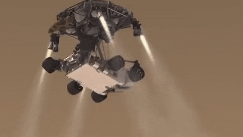
INCOMING! Roving scientist to arrive on Mars.
Save the date! One year from today, Feb. 18, 2021, our next rover is set to land on Mars. Get to know #Mars2020 now! Click here.
Make sure to follow us on Tumblr for your regular dose of space: http://nasa.tumblr.com
i cannot wait for my first solar eclipse! what's your favorite part about these eclipses, alexa?
I’ve never seen totality as the last time it was in the US was before I was born. My favourite part of seeing videos and photos is definitely viewing the solar corona! But I’m looking forward to this one so that I can see sunspots during the partial eclipse! It’s these spots that are often the active regions on the Sun that produce solar storms that can ultimately drive the aurora here on Earth!
Meet Our ICONic New Satellite
The boundary between Earth and space is complicated and constantly changing. Unlike the rest of the atmosphere, the upper atmosphere near the edge of space has a mix of both neutral particles similar to the air we breathe, as well as electrically charged particles called ions. Changes in this region are unpredictable, but they can affect satellites and garble signals, like GPS, that pass through this region. That’s why we’re launching ICON (the Ionospheric Connection Explorer) to get our first-ever comprehensive look at our interface to space.

About 60 miles above Earth’s surface, Earth’s atmosphere gives way to space. The change is gradual: The gases of the atmosphere get steadily thinner the higher you go. On the edge of space, the Sun’s radiation cooks some of those thin gases until they lose an electron (or two or three), creating a population of electrically charged particles swarming alongside the neutral particles. These charged particles make up the ionosphere.

Because the particles of the ionosphere are electrically charged, they respond uniquely to electric and magnetic fields. Dynamic conditions in space — including shifting fields and surges of charged particles, collectively called space weather — induce shifts in the ionosphere that can have far-reaching effects. The ionosphere is where space weather manifests on Earth, and it’s inextricably connected with the neutral upper atmosphere — so distortions in one part affect the other.

Changes in the ionosphere and upper atmosphere — including sudden shifts in composition, density, temperature, and conductivity — can affect satellites, building up electric charge that has the potential to disrupt instruments, and garble signals like those used by GPS satellites. Predicting these variances is hard, because the causes are so complex: They’re driven not only by space weather — usually a product of solar activity — but also by regular weather down near Earth’s surface.

Differences in pressure caused by events like hurricanes, or even something as simple as a sustained wind over a mountain range, can ripple upwards until they reach this region and trigger fluctuations. Weather’s influence on the upper atmosphere was only discovered in the past ten years or so — and ICON is the first mission designed specifically to look at that interaction.

ICON carries four types of instruments to study the ionosphere and upper atmosphere. Three of them rely on taking far-away pictures of something called airglow, a faint, global glow produced by reactive compounds in the upper atmosphere. The fourth type collects and analyzes particles directly.
MIGHTI (the Michelson Interferometer for Global High-resolution Thermospheric Imaging) uses Doppler shift — the same effect that makes a siren change pitch as an ambulance passes you — to precisely track the speed and direction of upper-atmosphere winds.
FUV (the Far Ultraviolet instrument) measures airglow produced by certain types of oxygen and nitrogen molecules on Earth’s day side, as well as oxygen ions on Earth’s night side.
EUV (the Extreme Ultraviolet instrument) measures shorter wavelengths of light than FUV. Airglow measured by EUV is produced by oxygen ions on Earth’s day side, which make up the lion’s share of Earth’s daytime ionosphere.
The two identical IVMs (Ion Velocity Meters) make very precise measurements of the angle at which ionized gas enters the instruments, helping us build up a picture of how this ionized gas around the spacecraft is moving.

We’re launching ICON on June 14 Eastern Time on an Orbital ATK Pegasus XL rocket from Kwajalein Atoll in the Marshall Islands, which will deploy from Orbital’s L-1011 Stargazer aircraft. NASA TV will cover the launch — stay tuned to nasa.gov/live for updates and follow the mission on Twitter and Facebook.
Make sure to follow us on Tumblr for your regular dose of space: http://nasa.tumblr.com.
-
 innerpolymathy reblogged this · 4 months ago
 -
 mount3 reblogged this · 1 year ago
 -
mount3 liked this · 1 year ago
-
 xrayallen liked this · 1 year ago
 -
 retaliationgraphics liked this · 1 year ago
 -
 metuere liked this · 1 year ago
 -
 little-red-bat liked this · 2 years ago
 -
 messy-insomniac-bookgirl reblogged this · 2 years ago
 -
messy-insomniac-bookgirl liked this · 2 years ago
-
 dancerinthestorm reblogged this · 2 years ago
 -
dancerinthestorm liked this · 2 years ago
-
 crema-torium liked this · 2 years ago
 -
 placeholdernr57 reblogged this · 3 years ago
 -
 so-fucking-gay26 liked this · 3 years ago
 -
 science-and-nature-art reblogged this · 3 years ago
 -
 p-r-a-x reblogged this · 3 years ago
 -
 thisisfouryou reblogged this · 3 years ago
 -
 pinkylover68 liked this · 4 years ago
 -
 incredible-fishes reblogged this · 4 years ago
 -
 lislaomedeia reblogged this · 4 years ago
 -
 wat-ney liked this · 4 years ago
 -
 yaredyadalecki liked this · 5 years ago
 -
 untimelypacifist reblogged this · 5 years ago
 -
untimelypacifist liked this · 5 years ago
-
 fillytoria liked this · 5 years ago
 -
 fae-bun liked this · 5 years ago
 -
 spark-is-tired reblogged this · 5 years ago
 -
 scriptorsecular liked this · 5 years ago
 -
 sedinae reblogged this · 5 years ago
 -
 wilord1 liked this · 5 years ago
 -
 sumvolismos liked this · 5 years ago
 -
 undercovercheetah reblogged this · 5 years ago
 -
undercovercheetah liked this · 5 years ago
-
 innumerablepolarbears liked this · 5 years ago
Explore the universe and discover our home planet with the official NASA Tumblr account
1K posts